How best to explain this land dispute? With pictures. (If you want the long, boring, written version, go here.)
According to the Waldorf School of Atlanta:
- The size/area/amount of land purchased in 2001, 2002, cannot fit the available space according to Waldorf’s legal deed; and
- An old private dirt road, Willard Avenue (which remained in private hands and was never dedicated to public use) was Warranty deeded to Conway Road owners in the 1940’s and 1950’s, and that just so happens to match the amount of land Waldorf is missing and thus – that land belongs to Waldorf.
So, here is the written record (public deed record), illustrated. At the time of these deeds, South Columbia Road was named “Flat Shoals.”
If you click each picture, it will open in a new browser tab or window so that you may view it better.
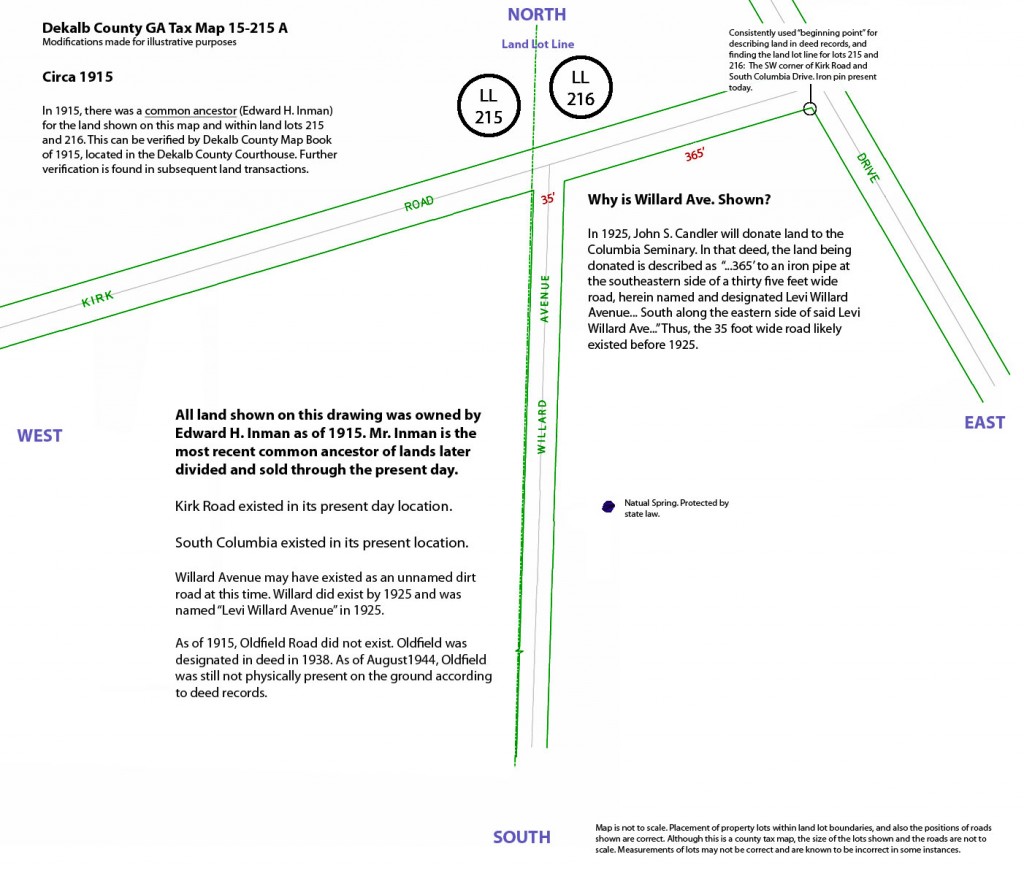
In 1915, and earlier, Edward Inman owned all of the land (and more) now in dispute:
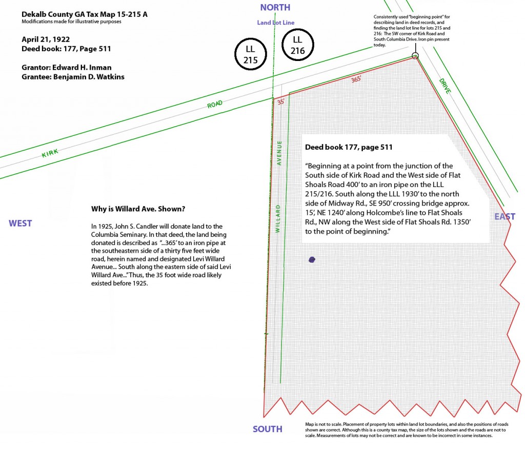
Seven years later, in 1922, Inman carved out a chunk and sold it to Mr. Watkins…
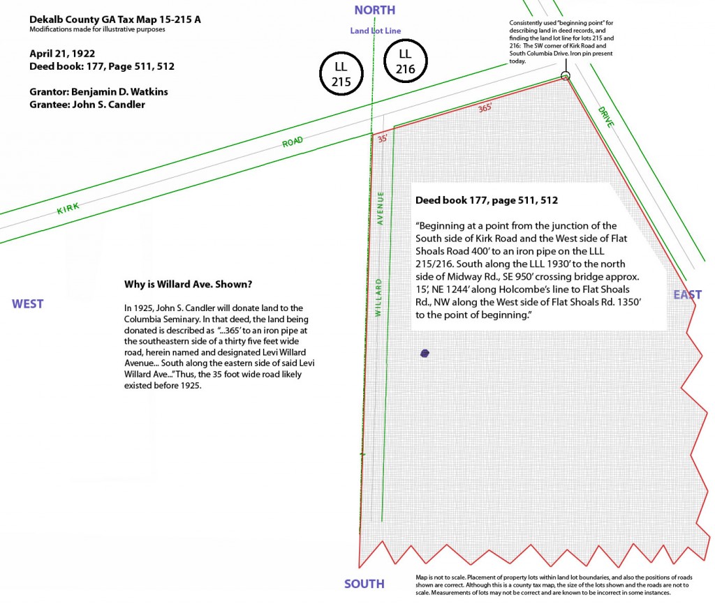
...who then turned around and sold it to John S. Candler
Before going further, let’s review a few points:
- Mr. Inman just carved out some land at a very specific point – “400 feet” from the corner of present day South Columbia and Kirk Road, that 400 foot mark also being the land lot line as established by the state back in the 1800’s.
- Mr. Inman still owned the remaining land to the west of the land lot line (area not shaded).
- Mr. Inman did not sell the same land twice – or any portion of it twice. When Mr. Inman divided his land and sold a portion to Mr. Watkins, that piece of land became the first piece of land sold from a common ancestor, which takes precedence over portions sold at a later time.
Let’s continue.
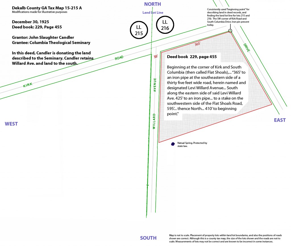
In 1925, Mr. Candler sells a portion of this same land to the Columbia Presbyterian Church.
And in that deed, he specifies Willard Avenue as:
- An existing, private dirt road (this is 1925); and
- Willard Avenue’s western boundary is 400 feet from the corner of South Columbia and Kirk and that 400 foot mark is also the land lot line as established in all prior deeds.
Mr. Candler holds on to this land for the next 20 years. In 1945, his heirs sell it to Ms. Harbin.
And wouldn’t you know it – it’s the same land – with the same dimensions – and the same language. The land lot line is at 400 feet.
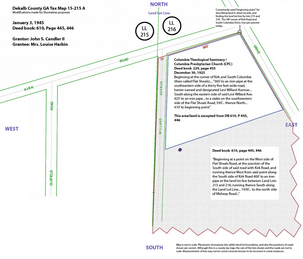
And 8 months later, Ms. Harbin sells the land to Mr. Walker
Once again – it’s the same land – with the same dimensions – and the same language. The land lot line is at 400 feet.
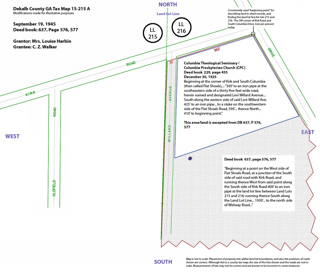
And what does Mr. Walker do? Why 6 months later, he sells it Mr. Ivey.
Once again – it’s the same land – with the same dimensions – and the same language. The land lot line is at 400 feet.
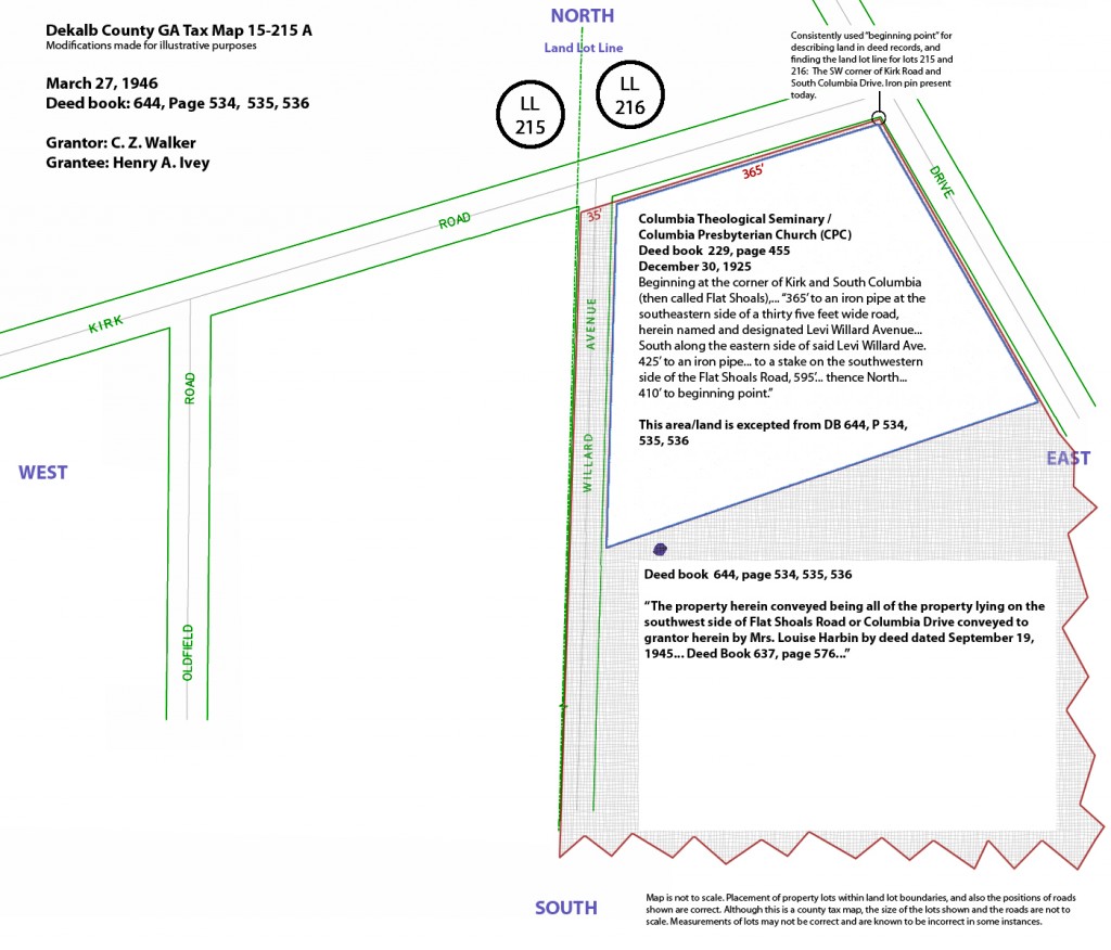
And then, Mr. Ivey builds… the houses we live in today on Conway Road.
But wait – where’s the mystery? Where’s the riddle? The hidden truth?
Well, turns out there is one little, tiny, itsy, bitsy detail. One little flip of words. One little thing called – “a scriveners error.”
A scriveners error is when the person typing a document – in this case, the deed Mr. Ivey just purchased – it’s when the person typing the deed makes a mistake.
And this is 1946. The war is over. Business is booming. Land is selling. Houses are being thrown together in mid air. And county clerks are typing their fingers raw on manual type writers that anyone born after 1990 has never seen.
And in 1946, when the deed is typed for Mr. Ivey’s purchase of land the clerk mixes his or her “east” and “west” on the deed when referencing the distance to the western side of Willard Avenue. This mistake is what Rose McConnell will focus on to start the dispute between the Waldorf School of Atlanta and neighbors on Conway Road.
But does it matter?
Actually, no.
How do you know it was a scriveners error? Because scrivener’s errors exist in almost all deeds available at the time – harmless typo’s such as misspellings, backwards measurements, east/west and north/south flips, etc. And usually, a corrective deed is issued – but not always. Often, the parties just accept the typo for what it is and keep going. After all it takes time, and often money too, to fix a typo.
But, one should always examine all previous deed(s) to confirm what is or is not a typo if something doesn’t look right. Waldorf’s attorney in 2008 – Rose McConnell – did not do that. She only researched the chain of title back to this one deed, and didn’t go any further. She shot first and asked questions never.
An example of a scriveners error can be found in Deed Book 603, page 583 (October 6, 1944). This deed concerns property on Waldorf’s western border, along Oldfield Road. In this deed, the direction of “southeast” is later corrected to read “southwest” but the correction doesn’t happen for another 10 and a half years, in May of 1955, (book 1089, page 465). As stated previously, scriveners errors happen all the time, but they are not always formally corrected, especially if the error is clearly visible on the ground.
But there is a far better way to know for sure that this was a simple typo. It’s easy and you can do it too. Here goes:
- When Inman sold his land to Watkins the dimensions were clear and precise. And, his land to the West was not sold until later.
- When Watkins then sold this same land to Candler, again, same language and dimensions. Same land lot line.
- When Candler sold some land to Columbia Presbyterian Church, again, same dimensions for the overall land. Same land lot line, and very, very specific language concerning Willard Avenue.
- When Candler sells to Harbin – same dimensions, same land. Same land lot line.
- When Harbin sells to Walker – same dimensions, same land. Same land lot line.
- When Walker sells to Ivey – same dimensions, same land. Same land lot line. And this transaction makes sure to express that the land being purchased is all of the exact same land Mr. Walker purchased from Ms. Harbin (common language at the time). In other words, you can’t say it’s the same exact land – and all of the land – as you purchased if you lop off 35 feet along the western edge by virtue of mixing up “east” and “west.” There is no doubt this was a scriveners error. And regardless of any errors, this deed does not convey any ownership to any property owner to the west.
So, within 14 months, the same land is sold three times, after having been held by the same owner for 20 years. No developments to the west. No changes.
The land lot line is stated as being 400 feet from the point of beginning since at least 1915, and through Mr. Ivey’s purchase in 1946, and through the present day.
Ms. McConnell simply found a scriveners error and latched onto it like a bulldog. She (apparently) failed to research the matter in the manner required for such an issue.
Future advice: before you piss on someone’s property, be sure you have a solid case for claiming it as your own.
As for Ms. McConnell’s claim that the land lot line is incorrectly located on the ground and in deeds, as a result of the scrivener’s error… Land lot lines are imaginary lines drawn up for purposes of handing out tracts of land in the early 1800’s when the lands were sold in Land Lotteries by the state of Georgia.
Land lot lines cannot be physically identified anywhere in the state of Georgia, they can only be inferred by written deed descriptions (at best). And every single deed description for this land lot line is specific – “400 feet from South Columbia and Kirk.”
No land lot line has ever been moved in the state of Georgia. No land lot line has ever been changed, or as Ms. McConnell wants to think of it – “corrected.”
The best explanation or guess as to why the Waldorf School of Atlanta now finds itself with less land than they thought they purchased is as follows:
- When Oldfield Road was paved (after 1946), it was likely misplaced and likely the county measured the distance to the center line of the soon to be Oldfield Road from the eastern edge of Willard, not the western edge, as they were supposed to according to deeds for the western side of the land lot line. The property deeds to the west of the land lot line are numerous, and all clearly use a point of beginning of 400 feet from the corner of South Columbia and Kirk Road.
- This would have overlapped the land which Waldorf later purchased by 35 feet. And in our same neighborhood, there are other roads that are also misplaced (Thomas Road is one example).
So, assuming that is the case, what does it mean for the Waldorf School of Atlanta?
- If the county did in fact overlap the properties by starting from the wrong point, if they failed to measure 400 feet from Kirk and Columbia as the common starting point for these properties, and then measured to the future center line of Oldfield, if that happened, it has no impact on the property owners on Conway Road. It’s not their problem.
- The Forrest Hills (Conway Road) development was started in 1946. It was platted first, before the Oldfield development, in addition to being the tract of land that was first out from the common ancestor (Inman). Thus, any mistakes to the west do not impact land to the east.
- As Mr. Ivey developed the homes on Conway, he quit claimed and warranty deeded the portions of Willard Avenue adjacent to each home, and the language in those deeds is very, very clear that Willard Avenue is in land lot 216, the same land lot as the homes he built on Conway. He could do this because his purchase of land included the private Willard Avenue. There was no confusion about the land lot line being located at 400 feet from South Columbia and Kirk.
- The Oldfield Road side development was not started until several years later. It was platted second.
- The land between the two developments (the land Waldorf owns today) was never platted on any development. It remained wooded and undeveloped except for along the northern edge, along Kirk Road.
- When Rose McConnell purchased the Waldorf property in 2001, that property located between the Conway Road and Oldfield Road Homes which had never been platted or developed, it looks as if she was just flat out sloppy. She made amateur assumptions and did not properly research the history of the land (a speculation of the quality of her work).
- The result is that 35 feet by (apx) 1200 feet of land on Waldorf’s western border is also deeded to properties on Oldfield Road. And that’s the thing that Waldorf doesn’t want to understand. Admitting that makes for a much more difficult fight than arguing a scriveners error and calling into question an old dirt road.
The history of our land on Conway Road is clear, concise and easily traceable in 6 simple deeds, spread out between 1915 and 1946.
The history of land to the West of the land lot line is also clear. But for Waldorf to pursue the actual mistake means they would have to sue their neighbors on the western boundary – not something they want to do. Or, as Rose McConnell stated in our June 28, 2008 meeting, “Who do you think our title insurance is more likely to settle with – you? Or the homes on Oldfield Road?” Or, shorter version: “those folks over there look like they have money for a fight – you don’t.”